GEO 302C EXAM 2 Fall 2003
The mean score of this test
is 78. Your grade was posted on eGradebook on
You may not refer to any other materials during the exam. For each question (except otherwise explicitly stated), select the best answer for that question. Read all choices before selecting an answer and make sure your choice answers the question asked.
1. Ignoring the contributions of wind, a baseball would be expected to travel a _______ distance in cold air than in hot air.
a. longer
b. shorter
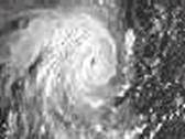
2. This satellite image shows a tropical
cyclonic system developed in the __________. a.
Northern Hemisphere. b. Southern Hemisphere.
3. Tightly packed isobars produce _______ pressure gradient forces and ______ winds.
a. strong, high.
b. strong, light.
c.
weak, high.
d. weak, light.
4. If surface air pressure decreases, the height of the column in a mercury barometer would:
a. remain constant
b. increase
c. decrease
d. change momentarily, but return to its earlier reading
5. If water than mercury were used in a barometer the height of the column in the barometer would:
a. increase significantly
b. decrease significantly
c. remain the same
d. not provide an accurate measure of atmospheric pressure
6. The unit of pressure most commonly found on a surface weather map:
a. inches of mercury
b. millibars (mb)
c. pounds per square inch (psi)
d. atmospheres
7. Sea level pressure is typically around
a. 2000 mb
b. 1000 mb
c. 500 mb
d. 100 mb
e. 10 mb
8. The surface pressures at the bases of warm and cold columns of air are equal. Air pressure in the warm column of air will with increasing height than in the cold column.
a. decrease, more rapidly
b. decrease, more slowly
c. increase, more rapidly
d. increase, more slowly
9. Which of the following instruments measures pressure?
a. barometer
b. thermometer
c. psychrometer
d. hygrometer
10. The surface weather map is a sea level chart. Thus, a surface weather map is also called:
a. a constant pressure chart
b. a constant height chart
c. an isobaric chart
d. a constant latitude chart
11. Lines connecting points of equal pressure are called:
a. isobars
b. millibars
c. contours
d. isotherms
12. Pressure changes:
a. more rapidly in the horizontal direction than in the vertical
b. more rapidly in the vertical direction than in the horizontal
c. at the same rate in the horizontal and vertical directions
d. more rapidly in the vertical over land than over the ocean
13. The Coriolis force is the force that causes the wind to blow.
a. true
b. false
14. Which of the following forces does not have a direct effect on horizontal wind motions?
a. pressure gradient force
b. frictional force
c. gravitational force
d. Coriolis force
15. Which of the following forces can not act to change the speed of the wind?
a. pressure gradient force
b. frictional force
c.
Coriolis force
d. none of the above
16. The force that would cause a stationary parcel of air to begin to move horizontally is called the:
a. Coriolis force
b. pressure gradient force
c. frictional force
17. Which of the following produces the strongest Coriolis force?
a. fast winds, low latitude
b. fast winds, high latitude
c. slow winds, low latitude
d. slow winds, high latitude
18. If the earth stopped rotating which of the following would not be true?
a. surface winds would blow from high toward low pressure
b. there would still be a Coriolis force
c. there would still be a pressure gradient force
d. there would still be a gravitational force
19. The vertical pressure gradient force is directed
a. downward
b. upward
c. horizontally
20. The winds aloft in the middle latitudes of the Southern Hemisphere generally blow:
a. from west to east
b. from east to west
c. from north to south
d. from south to north
21. Surface winds blow across the isobars at an angle due to:
a. the Coriolis force
b. the pressure gradient force
c. the frictional force
22. The wind around a surface high pressure center in the Northern Hemisphere blows:
a. counterclockwise and outward from the center
b. counterclockwise and inward toward the center
c. clockwise and outward from the center
d. clockwise and inward toward the center
23. We can generally expect the air to be above areas of surface low pressure and above areas of surface high pressure.
a. rising, rising
b. rising, sinking
c. sinking, sinking
d. sinking, rising
24. Which of the following associations is most accurate?
a. microscale - chinook wind
b. synoptic scale - sea breeze
c. mesoscale - land breeze
25. An instrument used to measure wind speed is called a(an):
a. anemometer
b. thermometer
c. psychrometer
d. barometer
26. An
extremely strong downslope wind that occurs in parts of
a. katabatic wind
b. Chinook wind
c. mountain breeze
d. monsoon circulation
e. diurnal breeze
27. Which of the following conditions favor the development of dust devils?
a. hot, moist days
b. hot, dry days
c. cold, moist days
d. cold, dry days
28. The
summer monsoon in eastern and southern
a. wet weather and winds blowing from land to sea
b. dry weather and winds blowing from land to sea
c. wet weather and winds blowing from sea to land
d. dry weather and winds blowing from sea to land
29. Which below is not an assumption of the single-cell model of the general circulation of the atmosphere?
a. the earth's surface is covered with water
b. the earth rotates once in 24 hours
c. the sun is always overhead at the equator
30.
a. northeast trades
b. southeast trades
c. westerlies
d. doldrums
31. The intertropical convergence zone (ITCZ) is a region where:
a. the polar front meets the subtropical high
b. northeast trades meet the southeast trades
c. northeast trades converge with the subtropical high
d. the Ferrel cell converges with the Hadley cell
e. polar easterlies converge with the air at the doldrums
32. In terms of the three-cell model of the general circulation, areas of surface low pressure should be found at:
a. the equator and the poles
b. the equator and 60o latitude
d. 30o latitude and 60o latitude
33. The
majority of the
a. westerlies
b. easterlies
c. northerlies
d. trades
e. southerlies
34. The world's deserts are found at 30o latitude because:
a. the intertropical convergence zone is located there
b. of the sinking air of the polar front
c. of the convergence of the prevailing westerlies and the northeast trades
d. of the sinking air of the subtropical highs
e. of the doldrums
35. Which of the following does not describe the subtropical jet stream?
a. generally blows from east to west
b. is found at the tropopause
c. is normally equatorward of the polar front jet stream
36. The average winds aloft are strongest in:
a. summer
b. winter
37. Which of the following is true about the oceans?
a. Approximately 3% of the total water on Earth is located in the oceans
b. The oceans cover about 30% of Earth’s surface
c. The average depth of the oceans is infinite
d. The sea surface is level for all the oceans
e. The oceans have a huge
heat capacity, so their temperature is less variable than the air temperature.
38. The largest reservoir of water on Earth is
a. oceans
b. ice caps/glaciers
c. lakes/rivers
d. atmosphere
39. What is the primary salt in the ocean?
a. CO2
b. FeO2
c.
NaCl
40. Major
surface ocean currents that flow parallel to the coast of
a.
b.
c.
d.
41. In
the Northern Hemisphere, the surface ocean currents in the
a. clockwise, counterclockwise
b. counterclockwise, counterclockwise
c. clockwise, clockwise
d. counterclockwise, clockwise
42. The
cold water observed along the northern
a. the
b. oceanic fronts
c. upwelling
d. cold air moving over the water
e. evaporation
43. The Ekman Spiral describes:
a. the turning of water with depth
b. the air flow into a center of low pressure
c. the circulation of surface water around a gyre
d. the air flow out of a region of high pressure
e. the wind-flow pattern in a jet stream
44. Upwelling is:
a. the lifting of air along the polar front
b. the rising of cold water from below
c. increasing heights in an upper-level ridge
d. the rising air motion found in a low pressure center
45. Upwelling
occurs along the northern
a. winds and the Ekman transport cause surface waters to move away
from the coast
b. of seismic activity on the ocean bottom
c. of gravitational attraction between the earth and the moon
d. water
flows from the
46. The
name given to the current of warm water that replaces cold surface water along
the coast of
a.
b. Humbolt current
c. Benguela current
d.
El Niño
e.
47. During a major El Niño event:
a. Peruvian fishermen harvest a record amount of fish near Christmas time
b. extensive ocean warming occurs over the central and eastern
tropical Pacific
c. the Northeast trade winds increase in strength
d.
e. climatic abnormalities are only limited to the tropical Pacific areas
48. A
condition where the central and eastern tropical
a. El Niño
b.
La Niña
c. the Southern Oscillation
d. the Ekman Spiral
49. The
reversal of the positions of surface high and low pressure at opposite ends of
the tropical
a. El Niño
b. the Southern Oscillation
c. upwelling
d. La Niña
50. Which of the following associations is most accurate for El Nino, La Nina, or both?
a. Both – Influence weather and
climate around the world
b. La Nina – Easterly trade winds weaken
c.
La Nina – The thermocline in the eastern equatorial
d. El Nino – Is part of ENSO process, but La Nina is not
e.
Both – A phenomenon in the