| |
Google Maps (GM), Google Mobile Maps (GMM) and Google Earth
(GE) use keyhole mark-up language (KML)
to store spatial coordinate and feature attribute information.
KMZ is a zipped (compressed) form of KML, allowing storage
of information from several KML files in a single archive.
To move map data to or from ArcGIS to Google Maps/Earth, ESRI
shapefiles/feature classes must be translated to KML or
vice-versa.
N.B. The horizontal datum for Google KMLs is a
sphere-based version of WGS84,
and coordinates are stored in decimal degrees - before
translating to KML, ESRI feature classes must be in geographic
coordinates with a ”WGS 1984 Major Auxiliary Sphere"
datum. Use the Projection tools
in ArcToolbox to convert shapefiles of projected coordinates to
geographic coordinates, if necessary, before using any of the
conversions tools described below. See
software tip #23 for further info. The vertical datum
for Google KMLs is WGS84 EGM96.
Common Questions:
1) How can I obtain a KML file of place marks, lines
or polygons for a Google Map (GM) (older versions)?
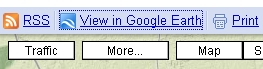
- Use the "View in Google Earth" link in GM,
shown above, to create a KML file that can be
saved to your computer. With a Firefox browser,
clicking "View in Google Earth" will return a
window that has an option to "Save File".
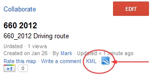
2) How do I do this in a newer version of Google
Maps?
- Newer versions of GM (late 2011 onward) no
longer have the interface shown in question 1.
Creating an account allows you to make custom
maps of routes or places, which can then be
saved as KML. It's a little harder to
find, but there is a download icon, as shown
below, available in "My Places" at the top of
the table of contents of one of your maps.
The icon is not visible when in EDITING mode.
 It's
that icon. It's
that icon.
3) How can I obtain a KML file of a "My Place" in
Google Earth (GE)?
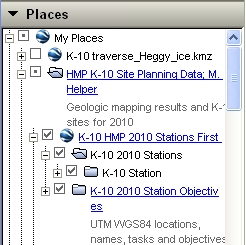
- KMLs of what is in your "My Places" exist on
Google servers. To obtain a copy using a
Windows computer, right-click on the folder or
locality icon in the "Places" area of GE and
select "Save As..". On an Apple computer the
same right-click menu is available (I think)
using the Control (or Alt?) key when clicking.
4) How do I convert a KML file to a Shapefile?
- ArcGIS 10 has an excellent conversion tool
in ArcToolbox for importing KML to a Geodatabase
feature class. It works very well for KML
files created in Google Maps or Google Earth.
- ***Another free option is to use an online
converter; the
one I like best is by
Zonum Solutions.
Most attribute data is preserved and the app.
does a good job with line and polygon KMLs.***
5) How do I convert a Shapefile to KML?
- ***Use an excellent ArcScript, "Export
to KML". This installs as an extension in
ArcMap and has many nice features. It was
developed by the City of Portland Bureau of
Planning.***
- The ArcGIS 9.3 ArcToolbox (and ArcGIS 10)
contains a "To KML" utility in the "Conversion
Tools" toolbox. It is not as nice as the City
of Portland's "Export to KML"
Some related questions for I-Phone users:
6) How can I view the "My Maps" of my Google account
on my I-Phone?
As of 2-23-10, Google Maps Mobile (GMM), an application that
runs on smart phones, displays Google Maps and a current
location marker on the I-Phone but does not provide a way to
access previously created custom Google maps ("My Maps") that
are stored within a Google account. Oddly, you can see your "My
Maps" in the mobile version of GE but not GMM. One
work-around to see a My Map outside of GE (but with no GPS
functionality):
-
Make your map and save it in My Maps.
-
Click "Collaborate" and send an invitation to
your email
-
On your mobile device, open the invitation
email and click on the URL.
The map opens in Google Maps on the Safari internet browser,
not GMM, so there is no GPS current location marker visible.
|
|
|