Rincon Home Page --> Rincon Eruption --> Volcanic Hazards Map
Volcanic Hazards Map for Rincon de la Vieja Volcano
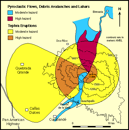
The greatest potential hazards at Rincon de la Vieja are to areas immediately north of the Active Crater, where 1) historic phreatic eruptions have produced small, yet far-traveled lahars (e.g., Barquero, l987); and 2) the eruption of the Rio Blanco tephra produced a northward directed pyroclastic flow. Stable volcanic deposits and topographic highs buttress the Active Crater on all but the northern flank, which slopes steeply towards the back arc plains (slopes exceed 30 degrees approaching the crater rim). Siebert (l984) showed that volcanoes with slopes greater than 20 degrees are highly susceptible to flank failure, especially those with slopes > 28 degrees. Given the analysis of Lopez and Williams (1992) concerning sector collapse of volcanoes due to hydrothermal alteration, this hazard is especially relevant for the Active Crater, which has maintained an acidic crater lake throughout its historic activity (Tristan, l921).
Preliminary geochemical sampling of streams along the north flank indicates that crater lake water is permeating through the crater wall rock and mixing with meteoric groundwater (Gary Rowe and Kirt Kempter, unpub. data). Leaching and alteration of the northern crater wall has therefore occurred, although it is not known to what extent or over what period of time. Given the steepness of the northern crater wall and its potential instability, sector collapse of this flank, associated with or without a volcanic eruption, represents the most serious threat to human lives, property, and ecosystem. A debris avalanche or major lahar directed northward would channel into the Rio Cucaracho canyon, and potentially flood the village of Birmania.
The uppermost volcanic sequence (<27,000 ybp) at Rincon is dominated by tephra deposits, especially in the summit region. Therefore, if a significant volume of magma (>0.1 km) is erupted in the near future, the eruption will probably be plinian, or at least vulcanian, in style. The zone which is likely to be covered by tephra is coincident to the dispersal pattern of the Rio Blanco tephra deposit, i.e., an asymmetric area to WSW of the Active Crater. ENE prevailing trade winds occur throughout the year, and older tephra deposits also show a westward, asymmetric dispersal pattern (although most tephra deposits peripheral to Rincon have been removed by erosion). The small pueblos (<3000 people) of Canas Dulces and Quebrada Grande, 19 and 17 km from the Active Crater respectively, are at greatest risk from a plinian-style eruption (~30 cm of Rio Blanco tephra were deposited at Quebrada Grande). The largest town in the region, Liberia (~ 30,000 habitants), lies ~ 25 km SSW of the Active Crater and may also be affected by a plinian eruption, especially if atypical wind conditions exist at the time of the eruption.
In the event of a magmatic eruption, the potential for a pyroclastic flow to occur is strong, possibly associated with a plinian event. Pyroclastic flows and lahars related to eruptions from the Active Crater are primarily a threat to the northern flank of the volcano, where historic eruptions have repeatedly destroyed vegetation and produced acidic, fast-moving lahars in Quebrada Azufrosa and Rio Penjamo. Several large haciendas on the northern flank of the volcano, including Seltiverio, Buenos Aires, and finca La Flor, are in the zone of highest hazard from eruptions that produce pyroclastic flows and/or lahars. The topographic amphitheater southwest of the Active Crater (in the dead zone) is also at risk, but is somewhat protected by an elongate volcanic ridge that separates the amphitheater from the Active Crater. Should a pyroclastic flow or lahar develop in this region, however, areas adjacent to the Rio Blanco and Rio Colorado are at greatest risk, especially the Las Pailas campground and the large haciendas Rincon de la Vieja and Guachipelin.
A major lava outpouring at Rincon is highly unlikely. Lava flows intercalated with tephras in deposits younger than 27,000 ybp are typically thin (<10 meters) and of minor extent. Aerial photographic observations of unmapped regions on the volcano's northern flank also fail to discern morphologies indicative of a major lava flow (e.g. flow lobes).
Back to Home Page
Pre-Rincon Geology |
Volcanic Hazards |
Rincon Geology