Rincon Home Page --> Pre-Rincon Geology (this page)
Geologic Map of Areas S and SW of Rincon de la Vieja
Field photos of QTpf, Qcd, Qbg |
Field photos of QTat, Qmt, Qgf |
The Liberia Tuff (Qlt)
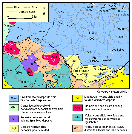
Caldera-related volcanism characterized much of northwestern Costa Rica during the Plio-Pleistocene, forming a broad ignimbrite plateau between the Caribbean and Pacific coasts. Although several major ignimbrites were erupted during this episode of volcanism (Dengo, l962; Tournon, l984; Setser, 1994), the only vestige at Rincon de la Vieja is located at the southern base of the volcano, just south of the hacienda Rincon de la Vieja. This and other Pleistocene calderas were closely coincident in space with the modern volcanic chain, but they have been buried by younger volcanoes and eruptive products.
The oldest volcanic units in this region (QTpf) consist of poorly welded ignimbrite deposits, fluvial and lacustrine sediments, diatomites, and intermediate composition lava flows. Stratigraphically above deposits of QTpf are voluminous, high-aspect-ratio, silicic lava flows and associated ignimbrite deposits that are moderately to densely welded (QTat). These lavas exhibit contorted flow banding characteristic of high-emission-rate, degassed lavas (Henry et al., 1988) which, similar to the lacustrine deposits, may have filled in a preexisting caldera structure.
Above the QTat lavas is the Liberia Tuff (Qlt), possibly the most voluminous rhyolitic ignimbrite in the region, and interpreted by Dengo (1962) and Healy (1969) to have erupted from a source at Rincon de la Vieja. The deposit is white to beige, poorly welded, and exposed over a broad portion of the Pacific coastal plains south and west of Rincon de la Vieja. The original extent of this deposit has been estimated by Chiesa (1991) to be 3,500 to 4000 km2, with an erupted volume of 25 km3. The ignimbrite is crystal-vitric and is often distinguished from other ignimbrite deposits in northwestern Costa Rica by its high content of quartz, sanidine, and biotite phenocrysts. Where exposed, the base of this unit typically exhibits 2-3 meters of pre-ignimbrite surge and plinian airfall deposits (a roadside quarry exposing these deposits is located at N-98.5, E-76.0 on the Curubande topographic map).
The caldera structure shown on the map is believed to be related to the eruption of the Liberia tuff. The name Guachipelin caldera is proposed for this caldera, after a large cattle ranch SSE of the Las Pailas geothermal site. Although most of the caldera structure has been buried by younger deposits, the southern topographic margin of this caldera is preserved, and coincides with a marked break in the volcanic stratigraphy. The association between the Liberia tuff and the Guachipelin caldera is supported by 1) the radial distribution of the Liberia tuff peripheral to the caldera margin, and 2) an increase in deposit thickness and the size of incorporated lithic clasts approaching the caldera margin.
Within the caldera margin intracaldera Liberia tuff is interpreted to be buried by younger ignimbrites and deposits from the modern volcano. Recent K-Ar ages (Alvarado et al., l992) indicate that the Liberia tuff was emplaced at approximately 1.6 ± 0.1 Ma. Four rhyodacitic lava domes (Canas Dulces hills (QTcd)) were emplaced prior to the Liberia tuff, perhaps as leaks from an evolving batholithic magma that later gave rise to the voluminous rhyolitic ignimbrite.
Three smaller-volume ignimbrites are exposed within the Guachipelin caldera and appear to have filled the caldera depression (Qgf), as they are not found outside the caldera margin. Two of these ignimbrite deposits are exposed along Rio Colorado south of Hacienda Guachipelin (Curubande, N-4.0, E-88.0). Toward the north, the ignimbrite deposits are unconformably overlain by Quaternary lahar deposits and lavas of Rincon de la Vieja.
The timing of the onset of Quaternary andesitic volcanism at Rincon de la Vieja is poorly constrained. However, fluvial boulder-bed deposits (Qbg) rest unconformably above ignimbrite deposits immediately outside the caldera margin (exposed in canyons along Rio Colorado, Rio Salitral, and Quebrada Dos Quebradas - Curubande, N-00, E-83.5; N-9.3, E-75.4), and may record this early activity. Lavas and lahars from the modern volcano (Qrvu) lie stratigraphically above the boulder-bed conglomerates and the aforementioned caldera-fill ignimbrites (Qgf).
Several geothermal manifestations occur along a northwest-trending lineation at the base of Rincon de la Vieja (Azufrales, Las Pailas, Las Hornillas, Borinquen). Soil mercury studies by Lescinsky et al. (l987) indicate that a fault parallel to the volcanic front underlies and connects the geothermal sites. Gravity and magnetic studies in the Las Pailas area by Quezada (l989) identify negative and positive anomalies associated with distinct volcanic lithologies and support the existence of two NNE-SSW faults that delimit the area of thermal activity.
Back to Home Page
Pre-Rincon Geology |
Volcanic Hazards |
Rincon Geology