Rincon Home Page-->Rincon Eruption--> Rio Blanco Tephra Isopach Map
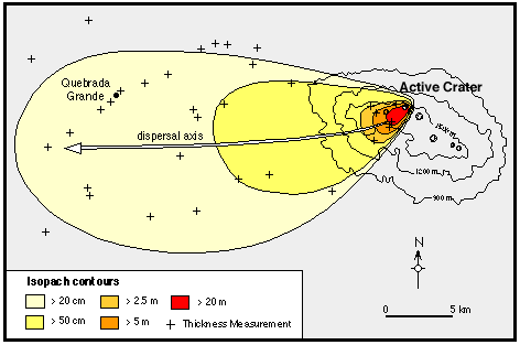
Isopach Map for the Rio Blanco Tephra Deposit

Field photographs of the Rio Blanco tephra deposit.
The Rio Blanco tephra, erupted from the Active Crater at approximately 3,500 ybp, was deposited in a highly asymmetrical dispersal pattern WSW of the source vent, indicating a strong prevailing wind from the ENE at the time of the eruption. The tephra is a well-sorted, lithic-poor lapilli airfall deposit that ranges in thickness from a few centimeters to greater than 20 m near source. The deposit is dominantly composed of pumice with phenocrysts of plagioclase, orthopyroxene, and rare hornblende. A pyroclastic flow associated with the tephra extends north of the Active Crater for several kilometers.
Grainsize studies of the deposit show that the proximal samples are very poorly sorted, while medial and distal deposits show a progressive increase in sorting efficiency. These studies also reveal that the eruption was sub-plinian, attaining an estimated column height of 16 km.
Isopleth maps of the deposit are similar in shape to the isopach map shown above. Each map is characterized by a curved dispersal axis. Near-source, the dispersal axis trends SW; with distance the axis bends progressively westward. These data suggest that two wind components affected the dispersal of the tephra; a component trending to the SW and one trending due W.
Most likely, tephra erupted high in the eruption column (> 9 km) was carried by westerly winds. Tephra fallout during less intense pulses of the eruption (lower column height) or from the periphery of the eruption column, was primarily transported by southwesterly winds. This scenario would also account for the thick deposits of tephra observed 1.0 - 1.5 km SW of the Active Crater.
Back to Home Page
Pre-Rincon Geology |
Volcanic Hazards |
Rincon Geology

