|
Student objectives
Students accept a large level of responsibility by agreeing to
participate in this program.
We have developed student projects designed to investigate these major
research questions:
-
What geologic history is recorded in rocks within the Menderes
Massif, and when were its large-scale structures operating?
-
Were the large-scale mechanisms that created the Menderes Massif
similar to those that produced extension elsewhere in the Aegean region?
-
What is the magnitude of extension accommodated by structures in
and surrounding the Menderes Massif?
Students will work on defined projects and will have concrete outcomes
(geologic maps, quantitative, and/or qualitative data).
They will work with igneous, metamorphic, and sedimentary rocks.
Each project that they will work on is substantial in scope (as opposed
to a collection of small projects), and have a reasonable chance of completion.
The objectives require contact with the geological literature and involve
a variety of techniques and instruments (as opposed to all library work).
They avoid repetitive work and students will learn advanced concepts they
likely will apply in future.
Prior to the trip,
-
US
Students should take a study abroad course
(for example
A&S 2000 Introduction to Study Abroad
. US students
should interview a Turkish student and
keep a workbook to help prepare for making responsible decisions in their new environment in
regard to finances, health, personal security while abroad.
-
Try
to learn Turkish
The Committee for
Economic Development has identified Turkish as one of the critical languages
that American students should learn to confront challenges to the US economy
and national security. Students will be partnered with Turkish students, some of whom may not speak
English very well. In 1993, Turkeys Higher Education Council (YOK) launched a
program to send thousands of Turkish students to study abroad. In assessment of
this program, researchers found that many Turkish students were unable to keep
up with work requirements of foreign universities, and were forced to accept a
MA in place of a PhD, or even leave programs without completing any degree. A
positive correlation was found between language proficiency and success. This program
helps Turkish students improve their English while working with American
students on common research objectives.
-
Conduct
library research Students should anticipate
visiting the Menderes Massif, and should learn about the geology of
western Turkey prior to the trip. Students should visit their university's
library and take advantage of resources to learn more about the
geology of Western Turkey prior to the trip.
-
Obtain
maps Geologic, topographic, and electronic
(e.g., NASA Worldwind and/or Google Earth) maps of Menderes Massif, the
targeted structures, as well as the Aegean in general are available.
-
Identify
specific and accessible sites for sample collection and/or places students want
to visit By understanding the geology and
geography of western Turkey, students are encouraged to identify places they
would like to visit and collect rocks and data.
-
Learn
the appropriate technology Students will
be required to collect oriented samples in the field using a Brunton compass,
record sample locations using Global Positioning System (GPS), and have an
understanding of how the geophysical equipment will be used in the field. The
field environment may be challenging and learning a new skill may be more
difficult than usual.
-
Be
prepared for international travel Students
passports should be up-to-date and all vaccinations should be completed. Students
should visit a doctor to discuss medications that they may need during the
trip.
Register the trip
Our budget includes $150 reimbursement for health insurance. Know about the
travel restrictions for carry-on luggage for international trips. Learn how to
access state department travel warnings. Be prepared for a long journey.
During the trip, students will:
-
Collect
rocks from geologically important locations
Students
will use a rock hammer, sledge, and/or chisel to collect a wide variety of
rocks from regions that we will analyze in the lab at a later time. Locations
of the samples will be determined using a GPS recorded in their field notebook.
They will use their Brunton compass to record the orientation of the samples.
-
Develop
geologic maps This will be done using the
topographic maps obtained in prior to the field season or from Turkish
colleagues. We will also devote specific days to allowing the students to
create their own geologic maps and cross sections using only graphing paper and
an outlined area.
-
Use
sophisticated geophysical equipment
Students will use a Scintrex CG5 Autogravimeter and Bartington magnetic
susceptibility system for taking field and laboratory measurements to
understand the development history of basins located in western Turkey. One basin we will focus on is the Denizli basin, of which little is known. Students will determine the geometry
and the thickness of the sediments in the basin. Students will conduct gravity
and magnetic surveys along profiles transecting the basin.
-
Interact
with their Turkish peers Students will be
partnered with their Turkish peers and be expected to collaborate with them on
specific projects throughout the trip.
-
Learn
about Turkish culture and history Historical
sites are also common throughout western Turkey, and the students can take
periodic one-day breaks from geologic work as the trip progresses.
-
Complete
an exit survey and program evaluation This
is required to improve experiences for future years. We also will be
disseminating what we learned to the broader geological community.
After the trip, students will:
-
Examine
the data that was collected Students can
enroll in independent study courses with one of the faculty participants in the
program. Students should meet regularly to work on their assignments in an
environment in which they will have a forum to discuss their new learning and
experiences.
-
Keep
in touch with their Turkish peers Students
will be expected to keep in touch with their Turkish peers via the internet
(instant messaging, penpal websites, email, facebook, etc) to communicate with
them about the progress of their research and practice written language skills.
-
Present
at a geological conference US undergraduate
and graduate students who have participated in international research will be
financially supported to present preliminary data at a local and/or national
conference.
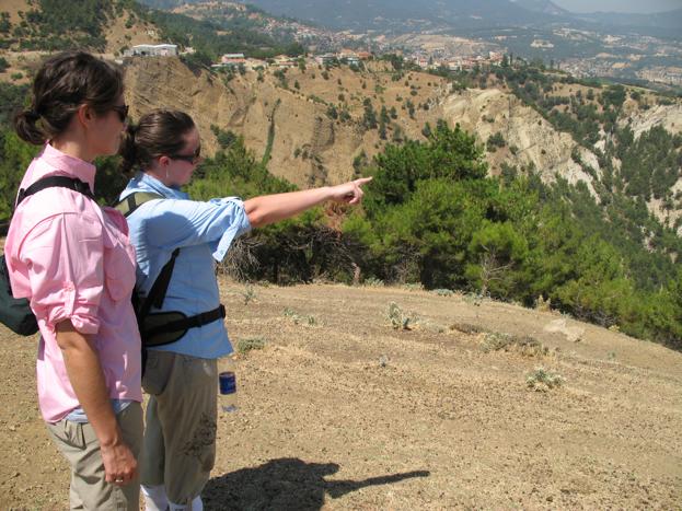
Students in the Denizli Basin during the 2008 field season.
|