|
GEO 381R Field Excursion to the Chilean Andes
In May, 1999, a combined group from the University of Texas
at Austin, New Mexico Tech, and the University of Utah spent three weeks in
northern Chile, experiencing the spectacular tectonic and volcanic geology of
the central Andes, the stark terrain and climate of the Atacama Desert, and the worldclass mineral deposits. The
trip was a fabulous educational opportunity for students with interests in
tectonics and subduction-related magmatism ((Karah Wertz, Tip Meckel), ore
deposits (Asif Muzaffar, Jim Corboy), and climate-related weathering phenomena
(Joy Griffin, Tony Troutman), as well as Pre-Columbian history and Andean
culture. The trip followed a Spring
Semester seminar in which the graduate students studied various aspects of the
geology of the region in GEO 381R Regional Studies in Mineral Resources Geology.
Each student prepared a section of a guidebook for the trip.
The trip included 10 geologic professionals who shared
invaluable experiences from the real world of mining and mineral exploration.
They and their companies also provided field vehicles and per diem
support that helped make the trip affordable for the students.
The Geology Foundation provided scholarships to cover most of the
international airfare for the students, thus making the trip an incredible value
for the students.
Chile is the world's leading copper-producing country, so
predictably the trip was dominated by tours of various types of copper deposits.
These deposits are hosted by Mesozoic and younger igneous rocks of a
variety of types. The deposits are
complex mineralogically, as the result of the variability of the original copper
concentrations and the overprint of weathering phenomena associated with the
hyperarid climate of the Atacama Desert.
The trip started in Copiapo, following an overnight bus
ride from Santiago. The first visit
was to the Candelaria copper deposit in Mesozoic metavolcanic strata, arguably
the most controversial deposit of the entire trip.
Next was a tour of El Salvador, the subject of many classic studies of
the relationship between hydrothermal alteration and "porphyry" copper
mineralization. El Salvador also
provided the only underground mine experience for the group.
We toured the new Manto Verde copper deposit, an interesting variety of
structurally controlled copper mineralization without a genetically associated
pluton. A day was devoted to
regional geology, including tracking the Atacama fault and coastal batholith
complex cut by spectacular dike swarms. We
ended up at the coastal town of Taltal from which we ventured out to examine
three manto-type copper deposits in Mesozoic andesitic volcanics.
Traveling further inland, we toured El Guanaco, an interesting study in
metal zonation from a high-level gold-rich deposit that becomes increasingly
copper-rich with depth. Lomas Bayas
provided an example of the climatically induced complexity to near-surface
copper deposits in the Atacama region, where the high nitrate and chlorine
content of the secondary ores complicates copper recovery via the solvent
extraction process. The nearby
Fortuna deposit illustrated a well-evaluated copper resource that awaits better
metal prices before production can commence.
El Abra, at 4200m elevation, provided the high point of the trip, with
one of the world's largest copper producers against a backdrop of snow-covered
Andean volcanic peaks. Mina Sur
(Exotica), the last copper deposit visited on the trip, was also one of the most
spectacular. Mina Sur formed where
groundwater, carrying copper derived during weathering of the nearby supergiant
Chuquicamata porphyry deposit, precipitated secondary copper minerals within the
matrix of Tertiary gravels forming a high-grade "exotic" deposit.
The Tejanos stayed after the conclusion of the mine trip to
see some of the other geologic features of northern Chile in the San Pedro de
Atacama area, one of the few habitable sites within the heart of the Atacama
region. This trip provided many
additional experiences, including an earthquake in Calama and a surreal sunrise
at 4,000m elevation at the steaming El Tatio geyser field after arriving in the
freezing dark. We visited the Salar
de Atacama, which contains the world's largest lithium producer from the
interstitial brines beneath a rugged evaporitic crust; the limited water in the
salar hosts a thriving biological community including a flamingo colony.
The visit was punctuated by an impromptu concert from a Chilean folk
group on the return bus to Calama. The
students made their way back to Santiago with an intermediate stop on the beach
at La Serena.
As was advertised for the course, the trip should not be
confused with a vacation. Although
everyone returned bone-tired, an unforgettable experience was had by all
participants.
Modified from story
by Rich Kyle in the 1999 DGS Newsletter
GEO 381R Field
Excursion to the Peruvian Andes
In May
2000, three University of Texas at Austin students, Marcy Davis, Amy Gilmer, and
Jenny Head, joined students and faculty from New Mexico Tech and the University
of Utah for a two-week field trip to study the geology of Per.
This was an excellent opportunity for students to see the unique mineral
deposits of Per, to experience Andean culture, and to meet geologic
professionals representing several mining and exploration companies.
The Geology Foundation provided scholarships to cover the international
airfare for the University of Texas at Austin students, and the Society of
Economic Geologists supported the trip through its field trip fund. The
professional geologists and their companies helped to support the per diem
expenses.
The
trip began in Lima with the first of two transects across the Andes.
The first transect began in the coastal batholith at Lima at sea level
and continued through the fold and thrust belt at Yauli Yacu (4816 m), then
descended to San Ramon (900 m) on the edge of the Amazon basin.
Crossing the entire Cordillera was a dramatic transition to experience
not only geologically, but also in terms of the vegetation and culture.
The
first mine visit was to the San Vicente zinc mine in the eastern Amazon owned
and run by SIMSA. San Vicente is
the 12th largest mine in Per with 1999 production of 940,000 tonnes
of ore averaging 8.5% Zn. The San
Vicente ore is distinctly banded within Jurassic carbonates and is similar to
Mississippi Valley-type lead-zinc ores that are believed to result from
metal-bearing basinal brines. The
group toured both the underground mine and the mill.
The La Oroya custom smelter operated by Doe Run Per provided an
opportunity to see how metals were extracted from their ore.
The La Oroya smelter produces 20 products from the polymetallic ores
mined in central Per.
The Yauli Yacu mine was the highest mine toured on the trip at an
elevation of 3700 m (12,135 ft). This
area, formerly known as the Casapalca district, contains complex Zn-Cu-Pb-Ag
ores in veins and in replacement zones in Cretaceous limestones and
conglomerates. The Yauli Yacu mine
extends laterally about 4 km and covers a vertical extent of 2 km.
The tour group was transported underground by train and then via an
interior shaft to a depth of approximately 1 km below the surface.
The group also visited several volcanic-hosted orebodies that occur
as roof pendants in the Coastal batholith about 50 km east of Lima. Initially
these deposits were mined for barite, but today Perbar is mining zinc-bearing
ore. The underground workings of the Cecilia Norte had a projected production of
540,000 tonnes for 2000. The
enigmatic orebodies of the Raul-Condestable district occur about 100 km south of
Lima. The district is primarily
known for its copper ore, but also produces some gold and silver ore as well. On
the return trip, the group visited the pre-Incan ruins at Pachacamac about 40 km
southeast of Lima. This area was inhabited before the time of the Incas along
one of the few irrigable valleys of the coastal desert.
To
save some travel time, the group flew to the city of Arequipa in southern Per.
Arequipa, the second largest city in Per, served as the base for the
second Andean transect. Arequipa is
surrounded by mountains, including the spectacular volcano, El Misti, whose
summit at 5822 m towers over the suburbs, offering an impromptu tutorial in
volcanic hazards. El Misti has been
active many times since historic records began, including a lava dome in the
1950s and current fumarolic activity. The
group traveled from Arequipa to Moquegua, crossing over the Incapuquio fault
zone, a major structure that is thought to be the extension of the Falla de
Domeyko along which the major copper deposits are localized in northern Chile.
Moquegua and surrounding region are known for the production of wines and pisco
(the typical and national drink of Per).
The focus of the
southern Per portion of the trip was the Tertiary intrusion-hosted porphyry
copper deposits, the continuation of the worlds largest copper belt in
northern Chile. All are huge open
pits producing copper to satisfy the global appetite for this important
industrial metal, particularly for electrical transmission. Weathering-related processes have produced large volumes of
low-grade copper concentrations that are suitable for bulk mining and
processing. Reserves of the
Southern Per Copper Co. at the Cuajone porphyry copper deposit are estimated
to be 1.24 billion tonnes at 0.64 % Cu. The
Cuajone deposit has experienced limited leaching and enrichment, perhaps because
of interruption of weathering by the eruption of the Huaylias tuffs that blanket
the area.
The Toquepala porphyry copper deposit about 50 km south of Cuajone
has a much
more extensive enrichment zone, perhaps because the Huaylias tuffs are absent in
this area. Tourmaline breccias and
anhydrite veins are common at Toquepala. Reserves
are estimated to be 700 Mt of 0.74 % Cu with an additional 1.1 Gt of leachable
ore at 0.20% Cu. The Cerro Verde
deposit owned by Phelps Dodge is located 30 km south of Arequipa, where the
highest copper concentrations occur in the potassic-altered core of the
intrusion.
The trip to Per was an amazing adventure and an experience not to
be forgotten. Everyone
learned a great deal about the mineral deposits and culture of Per.
Modified
from story by Amy Gilmer in the 2001 DGS Newsletter
GEO 381R Field Excursion to the Iberian Peninsula
In May 2001, graduate students Christine Fox, Karah Wertz, and James
McGuire participated in a tour of Portugal and Spain, a region with an ancient
mining history. The focus of the
trip was the Iberian Pyrite Belt (IPB) that contains numerous large
volcanic-hosted massive sulfide (VMS) deposits, the ancient equivalents of
modern sea-floor hydrothermal vent systems. The students spent Spring Semester
studying the geology and mineral deposits of the Iberian Peninsula, including
preparing a contribution for a guidebook on a topic of interest. Over two weeks, the students toured many of the larger ore
deposits in southern Spain and Portugal, as well as experiencing Iberian culture
and history. Thanks to generous
funding from the Geology Foundation, the students were able to gain direct
experience on the regional geologic framework and mineralization in Iberia that
they had studied in class.
The group, sponsored in part by the Society of Economic Geologists, met
in Lisbon, Portugal, and consisted of 22 students and professionals from the
University of Utah, New Mexico Tech, and the University of Texas at Austin (for
additional coverage, see http://www.mines.utah.edu/pyrite/spain2001/index.html
).
Fees collected from participating institutions and companies helped
defray transportation and housing costs during the IPB tour.
Group leaders were Dr. Bill Chavez of New Mexico Tech and Dr. Erich
Petersen of the University of Utah; local geologists provided a great deal of
detailed information at each major site.
The first stop on the tour was the relatively new Neves-Corvo mine,
outside of the small Portuguese hamlet of Castro Verde where the group enjoyed
terrific seafood. The Neves-Corvo
deposit is a blind orebody that was discovered almost entirely with
geophysics and is a very large VMS deposit characterized by high copper grades
and high tin zones. At Neves-Corvo,
the group learned the frighteningly simple, but effective, approach used when
logging core in the IPB: a basal metamorphic phyllite-quartzite (PQ), overlain
by a volcano-sedimentary sequence (VS), capped by the flysch group.
Typically, VMS orebodies like those at Neves-Corvo are found at the top
of the VS.
The next stop was the inactive Aljustrel VMS deposits that currently are
undergoing a feasibility study for zinc production.
Students examined cores for orebodies at Aljustrel that averaged 1% Cu
and 5% Zn, and learned an important lesson about how easily sphalerite can be
overlooked when logging core. The
group moved on to Lousal, a site of Roman tunnels precariously perched on steep
hillsides, where children were forced to labor in the gossan to provide gold for
the Empire. The Sao Domingo
deposits, next on the itinerary, are VMSs initially operated as an open pit by
the Romans, but more recently were used to provide pyrite for the production of
sulfuric acid. Acid mine drainage
from the workings had a pH of 2 (!), and both Sao Domingo and Lousal have
received attention recently as the Portuguese have begun to recognize the
environmental legacy of abandoned VMS mines.
Nowhere was these effects more apparent than at the groups next stop,
Spains historic Rio Tinto open pit mine.
At the mines museum, mining implements from the area believed to be
9,000 years old were displayed. There
has been almost continuous activity for the past 2,000 years, as the Romans and
Phoenicians initially exploited its riches.
In excess of 500 million tons of massive sulfide ore have been removed
from the main orebody. Rio Tinto is
so named because of the blood-red color of the river the captures all of the
runoff from the area. The Rio Tinto
has a pH of 2, and biologists who specialize in extreme environments study its
oxygen-generating bacteria, the only creatures hardy enough to live in it.
At Spains Aguas Teidas, Spanish for dyed waters, the group saw
more small VMSs with acid mine drainage problems.
Due to these historic environmental problems, the Las Cruces mine,
another Spanish VMS deposit visited by the group, has been developed with very
strict environmental standards. The
Las Cruces orebody has no surface expression and was discovered by drilling a
gravity anomaly. Production will
begin soon and Las Cruces will be one of Europes largest mines, meeting 6% of
its copper demands. After visiting
the Las Cruces offices in Seville, students were given a day to experience the
wonders of the city.
Los Frailes, the last VMS system visited, was perhaps the most infamous.
A tailings dam broke in 1998, spilling its contents down a river to a
sanctuary that is the breeding grounds for many European waterfowl.
Poor evaluation of the properties of the underlying marl led to the dam
failure. The resulting
environmental disaster is a primary reason that the mine is set to shut down in
the next year, though significant reserves and resources remain.
Witnessing disasters like this made everyone acutely aware of the need
for interaction between geologists and engineers in all phases of a project.
After Los Frailes, the group spent a day in Cordoba.
The days festivities included the Cordoba fair, visiting La Mezquita,
a Moorish mosque built 1200 years ago, and viewing Roman ruins.
The remaining destinations would be out of the IPB, examining some of the
other ore deposit types in central Spain and Portugal.
Almaden, a mercury deposit that is the worlds oldest continually
active mine, has accounted for at least one-third of global mercury production.
Regardless of the economic aspects, Almaden is a remarkable geochemical anomaly
essentially without equal for any element on the planet.
These stratabound cinnabar deposits are monometallic and thought to be
related to seafloor mafic volcanism. Grades
are as high as 20% mercury, but the cutoff grade is 3.5%.
Students descended to an active stope and broke open pieces of ore to
find droplets of native mercury and shiny red crystals of cinnabar in the shale
host.
The group explored the scenic mountain-top villa of Marvo, Portugal, on
the way to Panasqueira, the last tour on the itinerary.
Panasqueira is a tin-tungsten mine located in north-central Portugal, and
is known worldwide by mineral collectors for its assortment of large crystals of
quartz, apatite, arsenopyrite, and wolframite.
The two- to five-ft wide quartz veins that host the tin-tungsten minerals
formed during the Hercynian orogeny (~300 Ma).
After the mine tour, each member of the group was given a prize mineral
specimen.
Each member of the group returned to Lisbon having greatly increased
their respective knowledge of Iberian geology and ore deposits.
Equally impressive were the increases in luggage weight, as despite my
best efforts at being selective, my bag contained nearly 40 lbs of rocks!
The success of this trip, and previous GEO 381R trips to Chile in 1999
and Per in 2000, bodes well for opportunities for
future international field courses.
Modified from story by Mac McGuire
in the 2002 DGS Newsletter
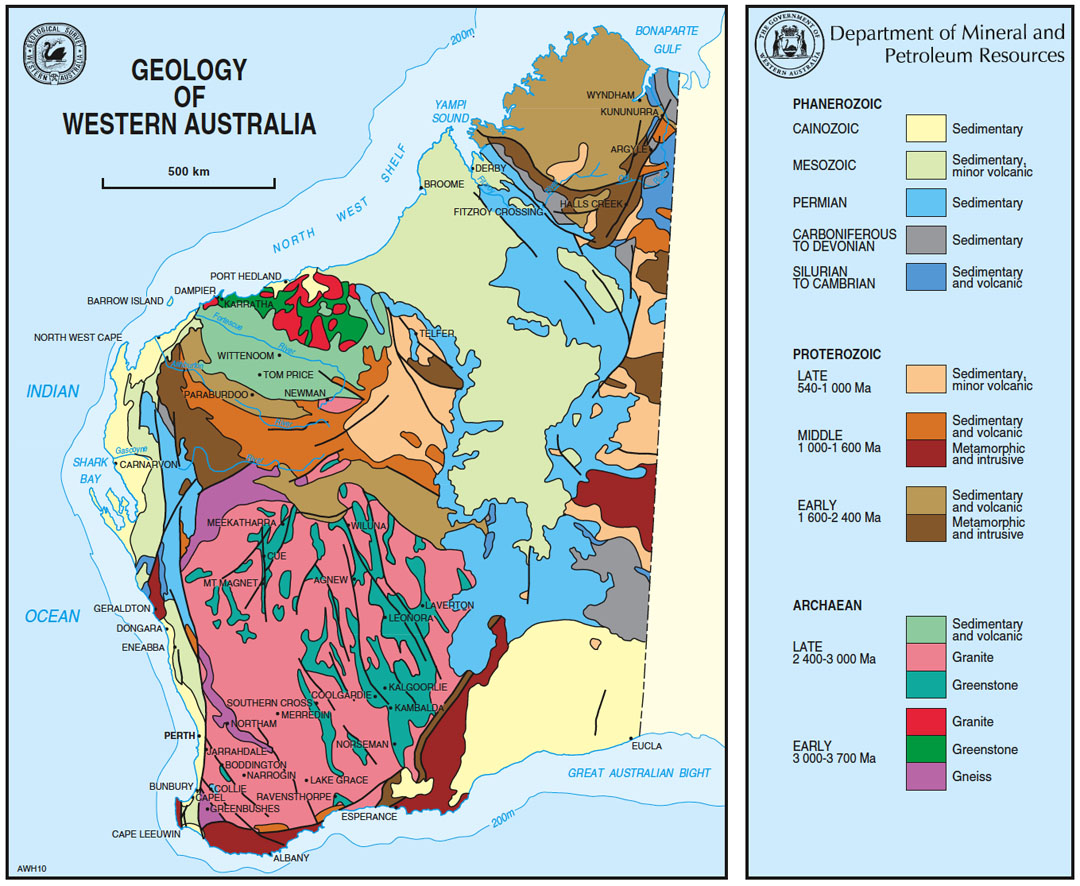
GEO 381R Field Excursion to Western Australia
The
2003 offering of GEO 381R was taught by Rich Kyle and Sharon Mosher and focused
on the Geologic Evolution and Mineral Resource
Development of Western Australia.
The
course culminated in a three-week trip to Western Australia in May 2003 that
provided an exceptional educational opportunity for 12 UT graduate students with
diverse interests to study many classic geologic sites. Western Australia offers an excellent 381R destination,
as it has varied geologic environments and is one of the worlds major mineral
producers. The Geology
Foundation provided scholarships to help cover the international airfare for the
students. Other costs were kept low
by camping for most of the trip.
This trip represented a return visit for a trip
that Sharon organized for a group of University of Western Australia graduate
students and faculty three years ago. Annette
George, Senior Lecturer in Sedimentology
& Basin Analysis at UWA, organized and led most of the trip, along with other UWA
colleagues and local authorities. The
trip began and ended in Perth and consisted of a
6,800-km clockwise traverse through a large part of Western Australia.
Following
a day for travel recovery and trip organization, the caravan headed north along
the Western Australia coast to Kalbarri with the first stop to look at the
Ordovician Tumblagooda sandstone and its trace fossils at Red Bluff.
The next day started with similar exposures along the Z-bend of the
Murchison River in Kalbarri National Park, followed by a long drive to arrive
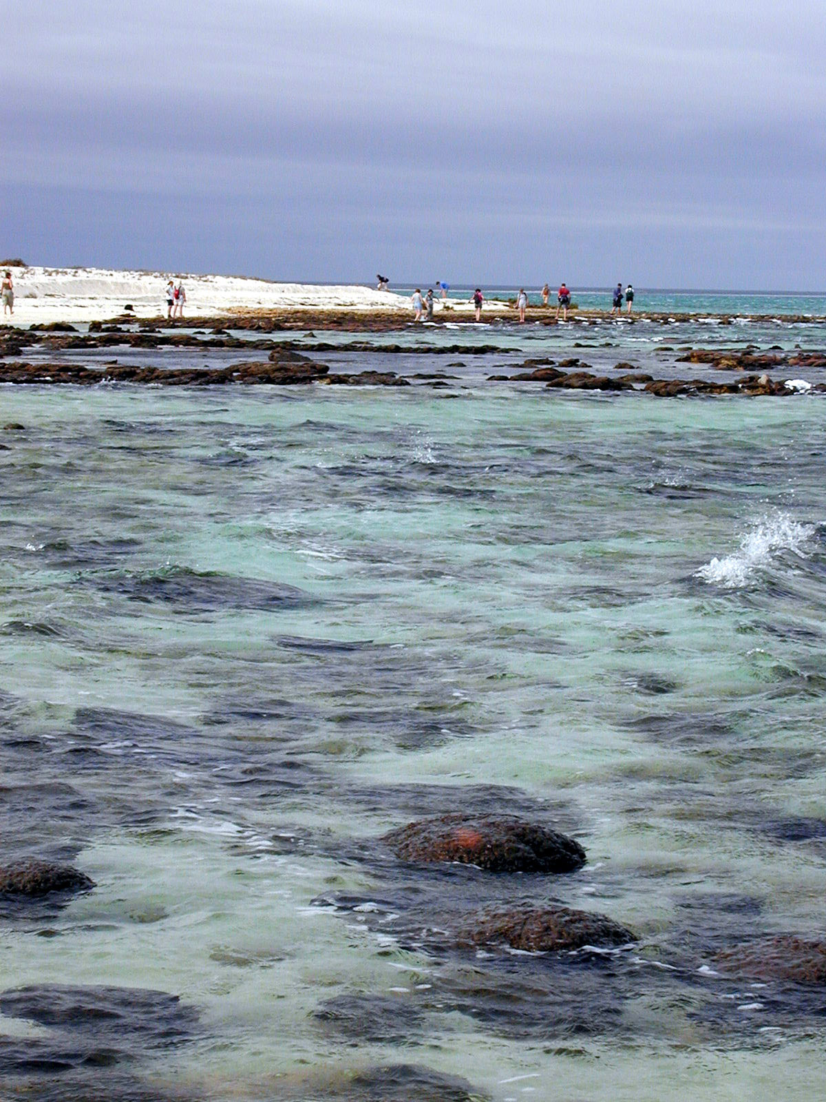
near dusk at low tide at the world famous modern stromatolites at Hamelin Pool
at Shark Bay. The next morning
provided an even more intimate experience with stromatolites and related
sediments at the Carbla
Point.
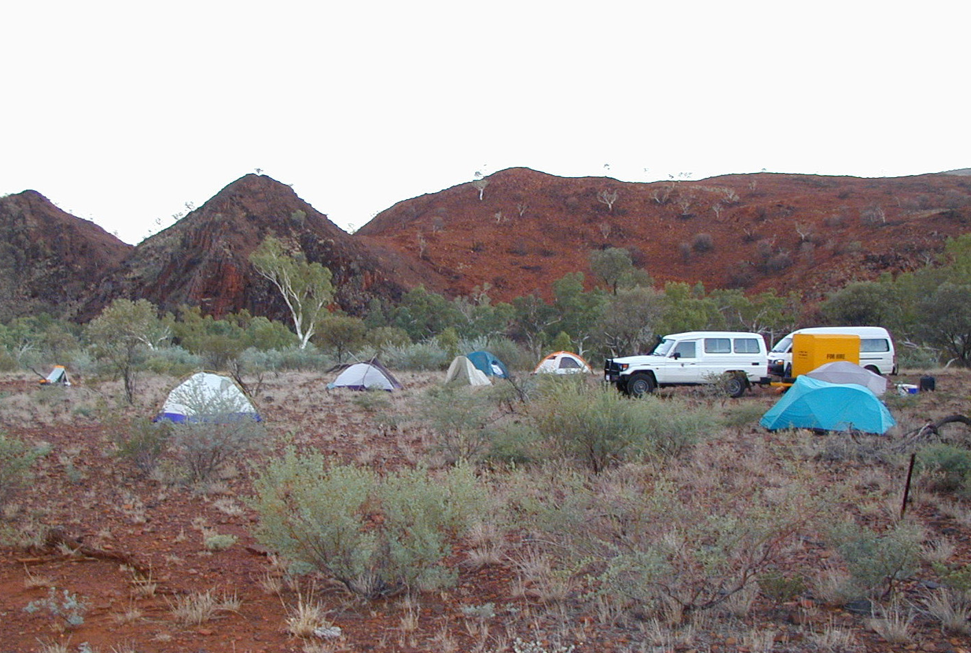
After
night in Carnavon and a dust storm along the coast, the group turned toward the
interior to begin a several day tour of the Hamersley Basin, known for its
extensive banded iron formations that supply much of the worlds iron for the
steel industry. The origin of these unusual sedimentary rocks remains
controversial, but commonly is tied to the evolution of the early Earth
atmosphere, hydrosphere, and biosphere. Extensive
exposures of the Hamersley Group were provided by traverses near Woongarra Pool,
the gorges in Karinjini National Park, and on Mt. Nameless (Jarndunmunha).
The group later toured the commercial iron concentrations developed from
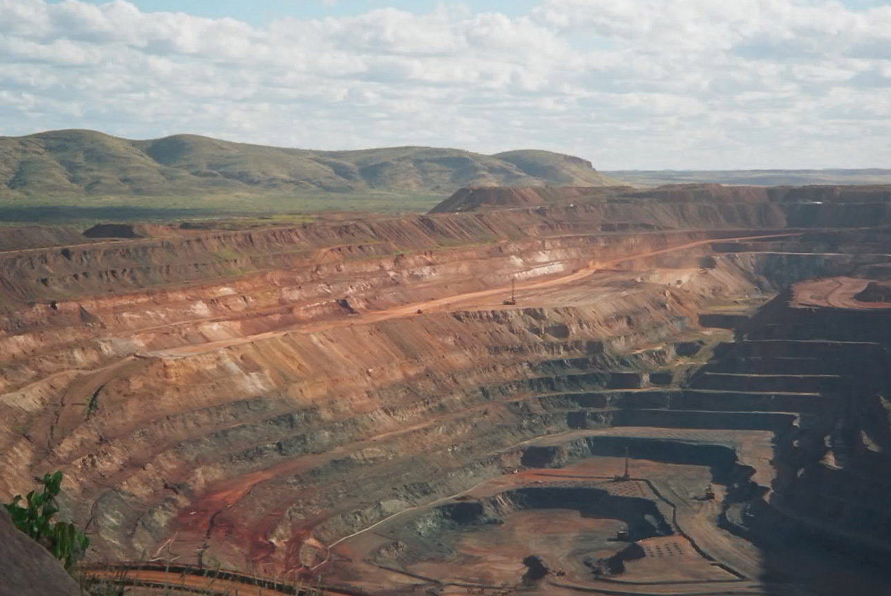
the BIFs at BHPs Mt.
Whaleback mine
near Newman that produces about 80 million tonnes of iron ore per year.
The
next major site was the Marble Bar and North Pole regions of the Archean Pilbara
Craton. The region represents one
of the worlds oldest greenstone-granite terranes with classic structural
styles, but of particular current interest are the silica- and barite-rich
chemical sediments on which much research continues in the search for early life
on Earth. These include the
controversial stromatolites in dolostones at the North Pole dome that are
arguably the Earths oldest biogenic structures.
Martin Van Kranendonk of the Geological Survey of Western Australia and
Malcolm Walter, Director of the Australian Centre for Astrobiology, and graduate
students from Macquarie University shared their extensive knowledge of the
geology of the region and on the early life issues.
Travels through the outback on the primitive tracks to view these
features provided considerable challenges for the rental minivan and the skills
of the driver!
The
group headed south to Newman, where Rich departed for the Geological Association
of Canada meeting in Vancouver and Annette returned to Perth for teaching
obligations. Warrick Crowe of the University of Western Australia guided the
group for the remainder of the tour. The
caravan continued with a long drive south to Kalgoorlie, one of the worlds
most famous gold mining regions within the Archean Yilgarn Craton, for a several
day visit. Kevin Cassidy of Geoscience Australia gave us an excellent overview
of the Yilgarn Craton and took us on a field excursion to see the Mt. Hunt
komatiite-felsic volcanic sequence; we were fortunate to have several other
geologists join us including Bruce Groenewald from the Western Australia Survey
and Chris Swager from a local mining company.
In contrast to the well-exposed Pilbara Craton, the Yilgarn is best
exposed in the mines or drill core. We
visited the gold mine superpit in Kalgoorlie and had a fascinating underground mine
tour of
a komatiite-hosted nickel-sulfide deposit in Kambalda, plus viewed core at the
mine and at the Geological Survey of Western Australia core library. A visit to the Mining Hall of Fame was gave us a good
historical perspective on mining in Western Australia.
The group next drove to the southern coast to see some superb exposures
of the Grenville-age Albany-Fraser belt. Warwick
Crowe led us along white sand beaches and rocky coves to spectacular structures
in multiply folded pelites at Hopetown and high-grade gneisses at Bremer
Bay. As we headed towards
Perth along the southern coast, we visited the Greenbushes pegmatite mine, a
major tantalum producer and high-grade lithium resource. On our last day we
drove to Perth with a brief tourist stop at Margaret River.
The trip to Western Australia was a great geoadventure and learning
experience, and we are grateful for the support of the School of Earth &
Geographical Sciences at the University of Western Australia, particularly
Annette George who converted our diverse interests into a working travel plan.
Discussions are already underway about destinations for the next
international field excursion.
Modified from story by Rich Kyle and Sharon Mosher in the 2003 DGS
Newsletter
Photo
1. Domal stromatolites in the Shark
Bay intertidal zone at Carbla Point, Western Australia.
Photo
2. Dawn at the GEO 381R campsite at Woongarra Pool in the Hamersley Basin.
Steeply dipping banded iron formations in the background.
Photo
3. Mt. Whaleback open pit iron mine
at Newman, Western Australia.
Photo
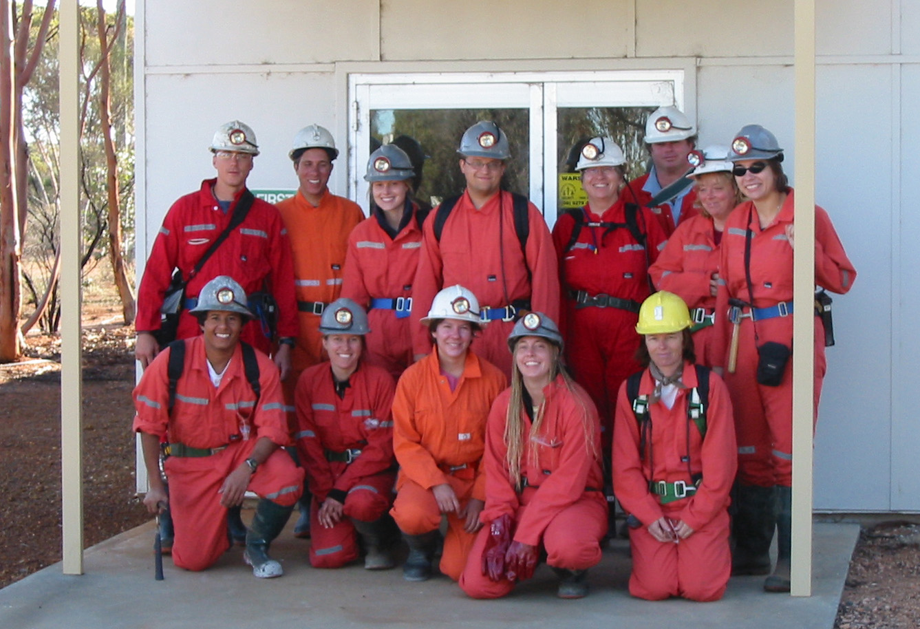
4. GEO 381R field trip group
prepared to go on the underground tour at the komatiite-hosted nickel mine at
Kambalda, Western Australia.
Photo
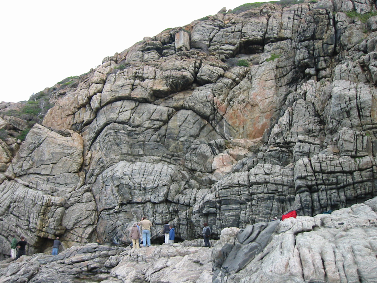
5. Large scale boudins in high
grade gneisses of the Grenville-age Albany-Fraser belt at Bremer Bay, Western
Australia.
If you have any questions or comments about the course, you may reach me at
rkyle@mail.utexas.edu.
|